
")
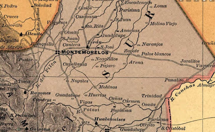
When researching ancestors from Northeastern Mexico, maps from the 19th century are invaluable. Among the most useful for family historians are the 1886 maps of Nuevo León, Tamaulipas, and Coahuila. These maps were created during a time of modernization in Mexico, and they offer unique insights into the geography, towns, and jurisdictions our ancestors knew.
Let’s explore what makes these 1886 maps so special and how they can be used in genealogy research.
Historical Context of the 1886 Maps
By the 1880s, Mexico was under the Porfirio Díaz regime, a period marked by rapid economic development, new infrastructure (railroads, telegraphs), and detailed territorial surveys. The 1886 maps reflect a clearer definition of state and municipal boundaries than earlier colonial-era documents, while still showing towns and ranchos that have since disappeared or changed names.
For genealogists, these maps serve as a snapshot of Northeastern Mexico just before large-scale industrialization and increased migration to the U.S. border.
Why These Maps Are Important for Genealogy
1. Locating Ancestral Towns and Ranchos
Many church and civil records from the 18th and 19th centuries reference places that no longer exist. On the 1886 maps, you can often find:
- Small ranchos that later merged into larger municipalities.
- Villages that were later renamed.
- Isolated haciendas that today are lost in the landscape.
This helps confirm where your ancestors lived and where to search for records.
2. Understanding Parish and Civil Jurisdictions
In genealogy, knowing which parish or civil registry office kept records is key. The 1886 maps show municipal divisions, which help you determine:
- Which church your ancestors likely attended.
- Where civil records (births, marriages, deaths) were registered after 1859.
- Why relatives may appear in different archives despite living close together.
3. Tracing Migration Patterns
The late 1800s was a time of movement across Northeastern Mexico and into Texas. By using the 1886 maps, you can:
- Trace likely routes your ancestors traveled.
- Understand proximity to rivers, roads, and railways that influenced migrations.
- Visualize connections between Monterrey, Saltillo, Matamoros, and border towns.
4. Reconstructing Communities
The maps often show not just towns but also neighboring ranchos, haciendas, and small settlements. This can help you:
- Rebuild ancestral regions
5. Comparing Past and Present Geography
Modern maps sometimes erase or absorb smaller settlements. By comparing the 1886 maps with today’s, genealogists can:
- Discover places that have vanished.
- See how towns expanded over time.
- Connect modern place names with those in your records.
Where to Find the 1886 Maps
Final Thoughts
The 1886 maps of Nuevo León, Tamaulipas, and Coahuila are more than just cartographic curiosities—they are genealogical tools. They help bridge the gap between old family records and the modern world, allowing us to place our ancestors in their historical geography.
By using these maps, you don’t just find where your ancestors lived—you rediscover their world.


